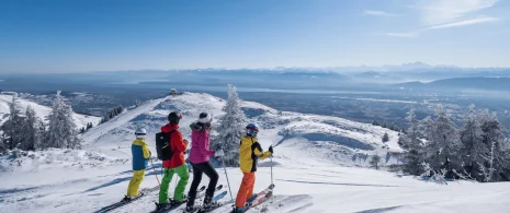


Starting in Lélex, this loop combines the main GTJ route with a variant via Mijoux and the Col de la Faucille. A varied route through forests, ridges and panoramic views, perfect for lovers of nature and wide open spaces.
3-day itinerary
▶ Day 1: Lélex → Mijoux (via the Haute Chaîne du Jura)
Approx. 6h10 – 16.8 km – D+ 985 m / D- 892 m
From Lélex, go to the old chapel and follow the GR (red and white markings). The route climbs to Ratou, passes the refuge de la Loge, the Col de Crozet, Colomby de Gex, Grand Mont Rond, then descends via the Col de la Faucille to Mijoux. An Alpine crossing with exceptional panoramas.
▶ Day 2: Mijoux → Les Moussières
Approx. 4h45 – 15.4 km – D+ 499 m / D- 324 m
From Mijoux, continue on the GR towards Lajoux, then on to Le Manon, Cariche, les Molunes, the bottom of Liasia, les Rasses and finally Les Moussières. A gentler stage in the heart of the Jura valleys and forests.
▶ Day 3: Les Moussières → Lélex
Approx. 5h45 – 19.9 km – D+ 424 m / D- 637 m
Start from Les Moussières following the GR towards La Muras, Pré Grandvaux, then skirting the Lac de l’Embouteilleux and crossing l’Emboissieux, au Berbouiller, le Berbois, la Borne au Lion, les Closettes and le Niaizet to return to Lélex.
Tip: it is possible to shorten the loop and complete it in 2.5 days, depending on your pace and preferences.
Stage 1: Overnight stay in Mijoux, with a choice of accommodation: the Gîte Communal de la Valserine, La Michaille or Les Berlicants.
Stage 2: Overnight stay in Les Moussières, with a choice of accommodation: Au Chalet, De La Platière or Refuge Sous La Joux.
Itinerary details
Description
This long loop offers a spectacular immersion in the emblematic landscapes of the Haut-Jura: crossing the Hautes-Combes, the Valserine valley and the majestic peaks of the Haute Chaîne du Jura. Between forests, mountain pastures and breathtaking panoramas, the route alternates between views of the Jura ridges on one side and Lake Geneva and the Alps on the other.
The route takes in the heart of the Haut-Jura Regional Nature Park, and part of the Haute Chaîne du Jura National Nature Reserve: a protected, unspoilt area to be explored with respect.
Good to know – Protected area
Part of the route passes through the Haute Chaîne du Jura National Nature Reserve, which is subject to special regulations:
Dogs are not allowed, even on a lead.
Camping in tents prohibited.
Please respect these rules to preserve the richness of this exceptional environment.


