


Snowshoes trail: from Catheline to Crêt de la Neige

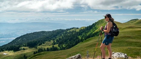
With snowshoes on your feet, set off to conquer Crêt de la Neige, the highest peak in the Jura at 1,720 m. Between unspoiled nature and panoramic views of Mont Blanc, the Alps, Lake Geneva and the Jura valleys, the experience promises to be memorable.
Itinerary details
Description
The Crêt de la Neige, the highest point in the Jura at 1,720m, can be explored in winter on snowshoes via a route that alternates between forests and clearings. Throughout the climb, there are numerous viewpoints: Mont Blanc, the Alps, Lake Geneva and Geneva, as well as Salève, the Écluse gorge and the Hautes-Combes in the Jura. Depending on the conditions, the lake may glisten in the sun or disappear under a sea of fog, creating a unique atmosphere. A wonderful outing in store.
Important information – Protected area
Part of the route passes through the Haute Chaîne du Jura National Nature Reserve, which is subject to specific regulations:
Please note that from December 15 to June 30, the trail crosses a wildlife quiet zone. Use of the trail is only allowed on condition that you stay strictly on the marked route and do not stray from it.
Dogs are prohibited, even on a lead.
Please respect these rules to preserve the richness of this exceptional environment.
Related offers
