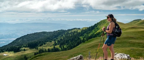



With its rich historical and natural heritage, this area offers a wide range of landscapes! Discover these treasures on walks along the riverbanks or hikes in the mountains.
-
-
Le Marais des bidonnes, ©AMbarbe -
Photo 2 -
Photo 3 -
Photo 4
See the route
-
-
-
The ridges at the edge of Roche Franche, ©NicodèmePeillon -
The ridges, ©AMbarbe -
View of Le Reculet, ©AMbarbe -
RNN Regulations, ©Canva
See the route
-
-
-
Le Reculet, ©jthevenard -
View of Le Reculet, ©tasdecailloux -
Crêt de la Neige, ©jthevenard -
Martagon lily on the ridges, © AM Barbe -
RNN Regulations, ©Canva
See the route
-
-
-
Hiking: Thoiry en Molie and the Hauts Sommets_Thoiry, ©Cyrille Pillet -
Mont Blanc view, © ThomasBalliard -
Orientation table, ©AMbarbe -
view, ©AMbarbe -
Le Reculet, ©AMbarbe
See the route
-
-
-
Vineyards in Dardagny, ©AMbarbe -
Vineyards in Challex, © White -
Border terminal, ©AMbarbe
See the route
-
-
-
Hiking: Gex – Vesancy – Chapelle Riantmont – Variant with dogs_Gex, © Thomas Baillard -
View of Vecancy, ©updrone -
View of Vecancy, ©updrone -
Beau chemin, ©AMbarbe
See the route
-
-
Hiking : Lélex – The Valserine, a wild river
Level easy
-
The bridges of Valserine, ©Annelegrand -
Valserine – Lélex, © Mr Beal -
The Valserine, © OTPG
See the route
-