


With its rich historical and natural heritage, this area offers a wide range of landscapes! Discover these treasures on walks along the riverbanks or hikes in the mountains.
The Tourist Office’s role is limited to providing information. To carry out your activity safely and minimise risks, we recommend seeking the assistance of a qualified mountain professional.
-
Hiking: the Baptiste stone
Level moyen
-
Le Pré Bouillet, ©ThomasBalliard -
Hiker on the trail, ©ThomasBalliard -
A little flower on the course, ©ThomasBalliard -
Hiker showing the Pierre à Baptiste, ©ThomasBalliard
See the route
-
-
-
Sunrise at Le Turet, ©jthevenard -
Bench, © AMBarbe -
Path, © AMBarbe -
Hiking trails, © AMBarbe -
RNN Regulations, ©Canva
See the route
-
-
Walking tour : Lélex – Truchet viewpoint
Level moyen
-
Valserine Valley – Lélex, ©Annelegrand -
View of the Valserine valley, ©AM Barbe -
View of the Valserine valley, ©AMbarbe -
Lélex village center, ©AM Barbe
See the route
-
-
-
Hiking: The Franco-Swiss route through the vineyards_Challex, ©Thomas Baillard -
Vineyards in Dardagny, ©AMbarbe -
Vineyards in Challex, © White -
Border terminal, ©AMbarbe
See the route
-
-
Walking tour : La Faucille – Les deux Montronds
Level moyen
-
Le Grand Montrond, ©NicodèmePeillon -
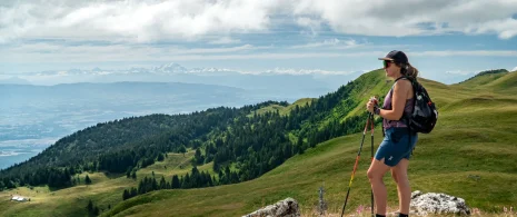
View from Petit Mont Rond, ©AMbarbe -
Beautiful view of the Lake Geneva basin, ©iAM Barbe -
Panoramic table, ©iAM Barbe
See the route
-
-
-
Le Marais des bidonnes, ©AMbarbe -
Photo 2 -
Photo 3 -
Photo 4
See the route
-
-
Hiking: Grilly – Mont Mourex
Level easy
-
Dolomite and the snow-capped Jura mountains, ©NicodèmePeillon -
The panoramic table, ©NicodèmePeillon -
Mount Mourex, ©AMbarbe -
Grilly Mont-Mourex hike, © AMBarbe
See the route
-
-
-
View of Le Reculet, ©tasdecailloux -
Crêt de la Neige, ©jthevenard -
View of Le Reculet, ©AMbarbe -
RNN Regulations, ©Canva
See the route
-
-
-
Walking tour : La Marche Populaire de Gex_Gex, ©Anne-Marie Barbe -
Branveau, ©AMbarbe -
cascade du Pissou, ©AMbarbe -
Creux de l'Envers, ©AMbarbe -
View of the Lake Geneva basin, ©AMbarbe
See the route
-
-
-
Hiking: Crozet to Crêt de la Neige via La Calame_Crozet, ©Juliette Thévenard -
View from Crêt de la Neige, ©AMbarbe -
Crêt de la Neige, ©AMbarbe -
The Alpage de la Calame, ©AMbarbe -
The descent to Curson, ©AMbarbe
See the route
-
-
Hiking: Forens – the Etrès waterfall
Level easy
-
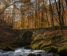
cascade in October, ©jthevenard -
Cascade de l'Etrès in September, ©AnaisBlanc -
Cascade de l'Etrès in July, ©jthevenard -
The Forens stream, ©jthevenard
See the route
-
-
-
The gentians on the Crêtes, ©jthevenard -
View of Mont Blanc, ©AMbarbe -
Cavité Crêt de la Neige, ©AMbarbe -
Highest peak in the Jura mountains, ©AMbarbe -
RNN Regulations, ©Canva
See the route
-