


Faulty beaconing, safety incidents, conflicts of use, illegal dumping? Locate and share the problem you have encountered on the national alert system via the SURICATE app or the https://sentinelles.sportsdenature.fr/ website.
(1) From the La Faucille Tourist Office, follow the yellow signs to the white path that runs under the Montrond telecombi. It also passes under the toboggan track structure. A few metres further on, an intersection appears.
(2)Turn left to begin the ascent. The road becomes a path that slaloms through the trees, skirts the ski slopes and follows the ski lifts. Climb 419 steps to reach Petit Montrond. Along the way, you’ll come across benches and viewing platforms.
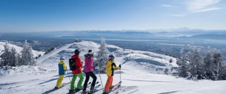
(3)The view from Petit Montrond (1540 m) is breathtaking: a 360° panorama, with Mont Blanc, the entire Alpine arc, Geneva, the Pays de Gex plain and Lake Geneva in the background. From the panoramic table, turn right around the antenna and pick up the ridge path on the other side. It alternates between ascents and descents before reaching the next crossroads.
(4)At the Vie de Chaux crossroads, take the GR (red and white) towards Grand Montrond. After a short climb, a descent leads to a mountain pasture and a cistern. Go around it to the left, then start the final climb to the highest point.
(5)The view from Grand Montrond (1596 m) is just as spectacular. Enjoy the view, then retrace your steps to the Vie de Chaux crossroads. From here, turn left on the GR and descend along the pasture. The path enters an undergrowth and reaches the Gélinottes ski lift.
(6)The trail passes under the ski lift, crosses a white road, then enters the woods to the right of the tunnel of the Gélinotte ski run. The descent through the forest continues for around 1 km, until you reach the Maréchaude forest road.
(7)Follow this road to the right, heading back towards the resort. It passes close to the giant zip-line, then skirts the Faucille shops to return to the starting point.