Loop
in Divonne-les-Bains

Walking: the Fleutron la Dole

A challenging hike with a steep gradient, alternating between deep forests and high Jura mountain pastures. The route crosses the Franco-Swiss border before reaching the summit of La Dôle (1677 m), offering a breathtaking 360° panorama.
Guidebook with maps/step-by-step

(1) Start at Le Fleutron, near the Huttopia campsite, above Divonne-les-Bains. Take the Vattay forest road, following the yellow signs. Turn left towards the Piste Cavalière. The first few metres follow a wide white track that runs alongside a small stream, crosses it and then begins a steep climb through the forest.

(2) Once you reach the Piste Cavalière, go straight ahead at the junction with a white track. The path climbs again until the next crossing of the forest road, with 110 m of ascent. Continue uphill on the same path: another 100 m of ascent to the pass known as La Combe de l’Eau.

(3) The path continues to climb, with a further 140m of ascent, until it crosses the Vattay forest road and reaches the Baraque de Divonne. From here, the slope becomes gentler. The path continues through the forest as far as a crossroads called Malassay, which marks the entrance to a quiet area closed from 15 December to 15 April. Continue straight on to the next crossing, called Les Rochettes.

(4) The climb remains gradual until you reach a point called Le Portail (1350 m), then the Col de Combe Blanche. The path descends slightly to join the forest road at the junction called La Cabosse.

(5) Follow the white track to the right towards La Grande Grand. The path climbs through the forest to the chalet, then leaves the wooded area and the quiet zone. There is a beautiful view of La Dôle from the heights of the Vattay plateau.

(6) Descend on the other side of the chalet to reach the Chalet de la Sonnailley and a forest road. This is where you cross the Swiss border. Follow the road to the right for around 200 m, then take the first junction on the left, still on a forest track. Climb until you find a path leading off to the right.

(7) The path climbs more steeply and reaches the ridge. It crosses a low stone wall and runs alongside it for around 700m. A final climb takes you to the summit of La Dôle (1677 m), the second highest peak in the Swiss Jura and the fifth highest in the Jura massif. The panorama from here is spectacular.

(8) To start the return leg, retrace your steps along the ridges for around 70 m and take the first path on the left, following it for 1.5 km to reach the Chalet de la Dôle.

(9) From this point, turn right onto the road and follow it for approximately 420 m. The path continues straight downhill and crosses the road 4 times, with several consecutive hairpins. At the 5th road junction, the path turns left before reaching the 3 maisonnettes du Bauloz.

(10) The path continues to the right. This part of the forest is slightly flat and rises. After a kilometre, it reaches a cleared area known as La Gerle. The path continues to the left, crosses the field and returns to the forest. It climbs back up to the right and eventually joins a forest road leading to the Combe de Faoug.

(11) The waymarked path continues to the left of the farm and climbs slightly at the end of the combe, crossing the border again. The path continues for 350 m before rejoining the forest road linking La Vattay to Divonne-les-Bains. Continue along this road as far as the Baraque de Divonne.

(12) From this point, pick up the path you used on the outward journey and take the same route back down to the starting point.

Itinerary details

Divonne-les-Bains
Loop
Marked
Ground, Hard coating (tar, cement, flooring)
Autumn, Summer, Spring
Pets are not allowed
From 16/04 to 30/11 daily.

Description

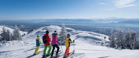
This superb out-and-back hike takes you from Divonne-les-Bains to the iconic summit of La Dôle. Demanding but rewarding, it is aimed at hikers in search of effort and grandiose scenery. The route crosses the Franco-Swiss border before reaching La Dôle, the second highest peak in the Swiss Jura (1677 m) and the fifth highest in the Jura massif. From its summit, the reward is just as high: a breathtaking 360° panoramic view of Lake Geneva, the Alps and Mont Blanc.
A wonderful mountain adventure, between forest shadows and open ridges, in a wild and peaceful atmosphere.

The route takes you through the heart of the Haut-Jura Regional Nature Park, and part of the Haute Chaîne du Jura National Nature Reserve: a protected, unspoilt area to be explored with respect.

Good to know – Protected area
Part of the route passes through the Haute Chaîne du Jura National Nature Reserve, which is subject to special regulations:

Dogs are not allowed, even on a lead.

Please respect these rules to preserve the richness of this exceptional environment.
Parking nearbyPedestrian sportsHiking itinerary
Duration09h30Elevation1254 D- / 1254 D+Distance21.4 kmAltitude Max.617 m
Download

Ce contenu vous a été utile ?