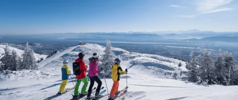
Itinerant hiking : From Mijoux to Confort via the Haute Chaîne du Jura
Embark on a wonderful adventure! Let's set off for a few days' roaming on the roof of the Jura, between Mijoux and Confort, with the aim of savoring every moment.
Itinerary details
Alert
The path below Charmy can be slippery in wet weat
Description
Departing from Mijoux, this tour takes you to the roof of the Jura massif.
The crests of the Haute Chaine du Jura promise breathtaking scenery. On one side, the view is of Lake Geneva and the Alps, on the other of the Haut Jura plateau.
In the heart of the Parc naturel régional du Haut-Jura and the Réserve naturelle nationale de la Haute Chaîne, the hike takes place in a protected natural area.
The trail is signposted as a GR® (red and white), and at the end of the itinerary part of it is signposted as a yellow PR®.
A journey of love with the Haute Chaîne du Jura
Your adventure begins at the Sentier des Arts in Mijoux, continues through Grand Montrond, Colomby de Gex, Col de Crozet, and leads you to the Refuge de la Loge for an unforgettable first night.
The Crêt de la Neige, the Reculet, the breathtaking panoramas of the Roche Franche, and a stopover at the Refuge du Gralet, where you can fall asleep.
This route is located in a nature reserve. Please respect the regulations in force:
Dogs forbidden, bivouacs in tents also forbidden.
Day 1: Mijoux -> Refuge de la Loge, approx. 5h30.
Distance: 13.6 km
Difference in altitude: 900 D+ / 448 D-
Route: leaving Mijoux and its charming frescoes, follow the red and white markings of the GR 9 as it climbs towards the Col de la Faucille. Turn right at the summer toboggan run. Follow Grand Mont Rond, then Colomby de Gex. Descend to the Col de Crozet and the Catheline cable car. Arrive at the Loge refuge.
Day 2: Refuge de la Loge -> Refuge du Gralet. Approximately 4 hours.
Distance: 11.2 km
Difference in altitude: 435 D+ / 435 D-
Itinerary: From the Refuge de la Loge, follow the signs for ‘sous le crêt’ for a good hour and a half to reach the highest point in the Jura massif: Crêt de la Neige 1720m. This beautiful aerial path then leads to the summit of Le Reculet (1719m) and briefly over various ridges. There is an alternative route for the more adventurous (weather permitting). A path leads to the Marie du Jura cave. The path then goes deeper into the undergrowth, before arriving at the Refuge du Gralet.
Day 3: Le Refuge du Gralet -> Confort, around 4 hours
Distance: 12.5 km
Difference in altitude: 124 D+ / 1003 D- I
Itinerary: from the refuge, head towards La Poutouille. The first part of the day is spent in the woods. Follow the GR9 up to the 6th kilometre. Begin the descent to Menthières (there are several possible routes.) At this point, continue for 2 km on the road (pass to the right of the ski lifts) as far as ‘Sous les Moraines’. Head towards Confort, and a small path over the Charmy ridges leads down to the village of Confort.
Confort: Transport: To return to Mijoux or to take the train to Bellegarde-sur-Valserine: Take the A53 line.