


Itinerant hiking : From Mijoux to Chézery-Forens via the Haute Chaîne du Jura


Set off on a great adventure! A few days roaming the heights of the Jura, between Mijoux and Chézery-Forens, with just one aim: to make the most of every moment.
▶ Day 1: Mijoux → Refuge de la Loge
⏱ Approximately 6.5 hours – 8.4 miles – Elevation gain: 900 m / Elevation loss: 448 m
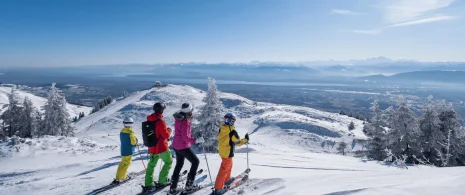
From Mijoux, with its typical narrow streets and murals, follow the GR9 (red and white markings) towards the Col de la Faucille. Turn right at the summer toboggan run, then climb towards Grand Mont Rond. Continue to Colomby de Gex, then descend to Col de Crozet and the Catheline cable car. Arrive at Refuge de la Loge, surrounded by nature.
▶ Day 2: Refuge de la Loge → Refuge du Gralet
⏱ Approx. 4.5 hours– 11.2 km – Elevation gain: 435 m / Elevation loss: 435 m
From the refuge, follow the signs for “Sous le Crêt.” After about 1.5 hours, you will reach the summit of Crêt de la Neige (1,720 m), the highest point in the Jura. The route, which is aerial and magnificent, then heads towards Reculet (1,719 m). As an option, an alternative route allows experienced hikers to reach the Grotte Marie du Jura. The trail continues through the woods to Refuge du Gralet, nestled in a forest setting.
▶ Day 3: Refuge du Gralet → Chézery-Forens
⏱ Approx. 4 hrs – 12.5 km – Elevation gain: 124 m / Elevation loss: 970 m
From Le Gralet, head towards La Poutouille through the undergrowth. Join the GR9 trail for 6 km, then begin the descent to Menthières (several variants possible). At the Col de Menthière, join the yellow PR trail towards Chez le Bon Claude and continue along the Grand Essert trail to Chézery-Forens.
Return transport
From Chézery-Forens, you can:
Return to Mijoux via the A53 highway
Or travel to Bellegarde-sur-Valserine to catch the train
Itinerary details
Description
Set off on a tour of the Haut-Jura between Mijoux and Confort, through a varied landscape of coombs, peaks and forests. Over three days, you'll traverse the crests of the Jura, passing by the Grand Mont Rond, the Crêt de la Neige and the Reculet, with magnificent views of Mont Blanc and the Alps. This crossing plunges you into the heart of the Haute Chaîne du Jura, for an authentic experience in the heart of nature. This is a self-sufficient route, so don't forget to bring your own provisions to make the most of this adventure.
Good to know – Protected area
Part of the route passes through the Haute Chaîne du Jura National Nature Reserve, which is subject to special regulations:
Dogs are not allowed, even on a lead.
Camping in tents is prohibited.
Please respect these rules to preserve the richness of this exceptional environment.
Related offers

Colomby de Gex
Free
