Loop
in Farges

Hiking: the Baptiste stone

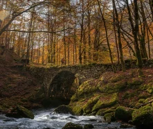
This beautiful forest trail leads to the “Pré Bouillet” chalet, from where you can admire a lovely view of the Salève. Discover the mysterious “pierre à Baptiste” along the way marked by cupules and carved holes.
Guidebook with maps/step-by-step

(1) From the center of Farges village, follow the yellow signs and turn left onto the main road. Pass the restaurant and turn right at the next intersection, turn right again at the fountain.

(2) Continue on the Chemin de Cazuet before taking the Col du Sac road on the left. After a bend in the road, fork left again onto a forest path winding through the trees. It first crosses the Col du Sac road, then rises steadily until it reaches La Pierre Baptiste.

(3) The Pierre Baptiste, an erratic boulder placed there when the ice melted, marks an altitude of 675m. From here, the climb continues through the woods. For the remaining 370m of the ascent, the path crosses the Col road four more times before reaching the highest point of the hike: Pré Bouillet (1045 m).

(4) At this point, the panorame opens up offering a beautiful view of the Salève. Walk alongside the house and cross to the other side to begin the descent. After crossing three successive intersections and continuing straight on, you reach Le Replat.

(5) The steep descent rapidly becomes a negative gradient before reaching the Col du Sac road. Just after the first bend, the path dips to the left and continues downhill. Gradually, the road reappears along with the first houses of Farges. Continue along the road until you reach the Chemin de Beudet, which closes the loop and takes you back to the starting point.

Itinerary details

Farges
Loop
Marked
Stone, Ground, Hard coating (tar, cement, flooring), Grit, Not suitable for strollers
Autumn, Summer, Winter, Spring
Pets are allowed
All year round.Subject to favorable snow and weather conditions.

Description

Departing from Farges, this hike alternates shady paths with open views. On the path winding through the forest, an imposing erratic rock known as the “Pierre à Baptiste”, a glacial rock with intriguing markings carved by “Sieur Baptiste”, who hoped to break it open to reveal its secrets and exploit it. The ascent continues to the Pré-Bouillet chalet, from where there is a superb panoramic view of the Salève and surrounding mountains. The descent then passes through clearings and undergrowth before reaching the first houses.
Car parkFree car parkPedestrian sportsHiking itinerary
DifficultyMediumDuration03h30Elevation534 D- / 534 D+Distance6.8 kmAltitude Max.518 m
Download

Did you find this content useful?