

Cycling route: From the Jura to Lake Geneva
The Jura to Lake Geneva loop connects the Pays de Gex to the Swiss shores of Lake Geneva, passing through Divonne-les-Bains, Céligny and Founex. A varied route combining the Jura’s mountainous terrain with the atmosphere of the lake.
These road bike itineraries are for guidance only, and are aimed exclusively at experienced cyclists.
Important information before you set off:
▶These routes are not marked on the ground and require the use of a GPS or navigation app.
▶The routes use roads open to motorized traffic. Compliance with the Highway Code is mandatory.
▶These routes are recommended for experienced cyclists in good physical condition who have mastered the art of road biking.
▶We advise you to check weather conditions before setting off and adapt your outing accordingly.
Start / Finish: Thoiry
Km 0 — Start
Head north-east along the road. A gentle warm-up over 1.2 km.
Km 1.3 — Towards the D89 (Route de Crozet)
Turn left and follow the D89 for about 1 km.
Km 2.3 — Cycle path
Join a cycle path via several junctions. Safe section for approximately 3 km.
Km 5.7 — Back on the road (D89)
Alternate between the cycle path and the road towards the plain.
Km 8.0 — Towards Route de la Source / Naz-Dessus
A series of small country roads. Slightly undulating terrain.
Km 10 — Sergy area / Gex countryside
Secondary roads, little traffic.
Km 12 — Back towards Gex
Pass through the town centre then head out towards the plain.
Km 14 — Towards Divonne-les-Bains (D1005 / D15h)
A smoother section with moderate traffic.
Km 18 — Chemin de l’Etraz / transition to Switzerland
A quieter road, slightly uphill terrain.
Km 21 — Crossing into Switzerland
Gradual entry into a more lakeside atmosphere.
Km 24 — Residential area and secondary roads
Alternating small roads and urban areas.
Km 26 — Short U-turn / route adjustment
Resuming towards the lake.
Km 28 — Towards Céligny
Fast-paced section with lovely open views.
Km 31 — Towards Founex
Wide, fast roads near Lake Geneva.
Km 35 — Passing through Swiss villages
Peaceful atmosphere, generally flat terrain.
Km 38 — Return towards the French border
Slightly hilly terrain on the way back.
Km 43 — Towards Sauverny
A mix of country roads.
Km 47 — Ségny / Cessy area
Side roads and through villages.
Km 54 — Cycle path
A safe section to finish the route.
Km 58 — Return to the starting point
Final rolling kilometres.
Km 59.5 — Finish 🏁
Itinerary details
Alert
A road shared with motorists.
Description
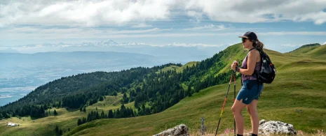
The Du Jura au Léman loop offers a complete and varied itinerary starting from the Pays de Gex, combining Jura relief, village crossings and escapes to the shores of Lake Geneva.
The route begins with a gradual warm-up towards Gex and its heights, before descending to the plain on rolling secondary roads. After an initial section through the countryside and villages of Gex, the route gradually shifts towards Divonne-les-Bains, the gateway to Switzerland.
The second part of the route skirts the shores of Lake Geneva, passing through Céligny and Founex, offering a more open and luminous atmosphere, with rolling sections ideal for maintaining a good pace. The return journey then takes in the countryside between Switzerland and France, alternating between small roads, villages and gentle hills until you reach your starting point.
A well-balanced route, with gentle climbs, long rolling sections and more technical sections, in an exceptional natural setting between the Jura and Lake Geneva.
This road bike itinerary is intended as a guide only, and is suitable for regular to experienced cyclists.
▶▶Important information before you set off:
This route is not marked on the ground and requires the use of a GPS or navigation app. The route takes in roads open to motorized traffic: compliance with the Highway Code is essential. Make sure you’re in good physical condition for the distance and gradient involved, and check the weather forecast before setting off.