


Circuit VTTAE – the Hautes Combes

This loop is a great way to discover the Haut-Jura plateau, so take a stroll through the dolines!
From La Faucille, head for Mijoux on the GR9 (red and white), downhill on the ski slope.
Once in Mijoux, stay on the GR9 via rue Royale, the route passes to the left of the church, then climbs to the right of the road, continue on this path until you reach the intersection at la Goulette, continue straight ahead on the yellow PR (caution: tricky passage).
Head for “la Loge”, the path through the woods is wide and rolling. You’ll come to an intersection of 3 paths, take the one furthest to your left (still marked in yellow).
This part of the path is finer and a little more technical, follow it to the “cabane de chasse”. Go back up to the Croaby crossroads.
Here, turn left (the path is not too visible for 20 m.) and you’ll come to a bicycle crossing. Cross it and follow this road until you reach Bellecombe by the “Humberts”.
Turn right on this road as far as the Simard crossroads, and go straight on towards Les Molunes. Before reaching this village, pick up the GTJ mountain bike on your left, and continue on this route to the village of Le Manon.
Take the road to Lajoux, exit the village on the right. Take the GR path in front of you towards Trécombe. From here, descend to Mijoux.
Return to La Faucille along the same path you took on the outward journey.
Itinerary details
Alert
A technical section can be avoided by taking the main asphalt road between Mijoux and Lajoux (this technical section requires very good driving skills).
Description
You'll be riding on all types of terrain: single, white, stony … and tarmac roads to make it easier to get through the fairly technical zone.
The profile is just as varied: steep climbs/descents, or steady, flat, downhill; rolling, not so rolling.
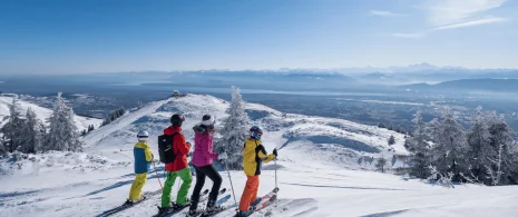
Beautiful panoramas line the route. It passes through valleys, forests, clearings and plateaus.
Pause for a moment of contemplation!
To be discovered!