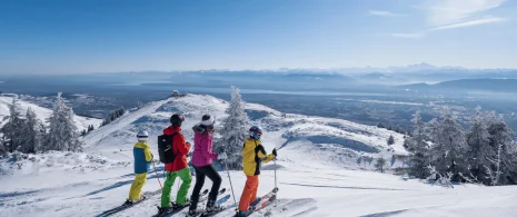


This traverse will take you through the most beautiful panorama in Europe. The view of the Alpine arc is breathtaking, from the Münch to the Massif des Belledonnes, 520 km of views just for you!
Guidebook with maps/step-by-step
Please note : this itinerary is signposted for hiking, not trail running.
From the Mijoux Tourist Office, walk up the rue royale to the sentier des Arts. You’re now on the GR9 (red and white).
Continue in this direction until you reach the Col de la Faucille, next to the Petite Chaumière.
From here, climb up to the Mont-Rond gondola departure point. Head towards Petit Mont Rond along the yellow PR path.
A pretty gravel path with steps awaits you. Once you’ve reached the antenna, continue along the ridges (yellow markings) to Le Crozat.
Pick up the GR9 and climb to Grand-Mont-Rond.
Continue on the GR9 to Col de Crozet, then to the refuge de la Loge. Return to Lélex.
Itinerary details
Description
The route is varied (undergrowth, ridges, white paths, dirt roads…) The climbs are fairly regular and not too technical. The terrain is rolling.
On the crests, the profile is undulating. The scenery is sumptuous, the views endless.
The stone is limestone, friable and can sometimes roll off your feet.
The route is located in the Haute Chaîne du Jura National Nature Reserve, so please respect the regulations specific to this area, these rules: dogs are forbidden, even on a leash!