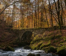
Lovely family walk all along the river. Some boards will inform you on the importance of water and watermills in the past. Picnic tables are available on site.
(1) Start [A] – Chemin de la Source (car park).
Follow the small road/path northwards along the Allondon. Pass the two ‘P’ car parks and enter the undergrowth.
(2) Right bank of the Allondon.
Leave the road and follow the forest path that runs alongside the river (the ground is sometimes wet and there are roots, so take care). Continue towards the resurgences.
(3) Sources of the Allondon [B].
Reach the Sources area (signs/emergences). Walk to the resurgences and back, then return a few metres along the same path.
(4) Option: loop via the western flank.
From [B], take the path that climbs to the left (west). It climbs in small hairpin bends then heads south along a balcony above the valley (pink line on the map) before joining a forest track.
(5) Return to the bottom of the valley.
Follow the track south to descend and rejoin the Chemin de la Source near the car parks. Turn right to return to the starting point [A].
(6) Pond/Route de Mury variant [C].
From the lower part, you can extend the walk to the right along the small road to Route de Mury [C] (ponds/wetlands), then turn back to return to [A].
Advice: stay on the marked paths, as the banks are slippery in wet weather and the area is sensitive — do not stray from the paths.
Itinerary details
Description
Fed by water seeping down from the Jura, the Allondon is a resurgent stream that flows from several springs at the foot of a small rocky overhang. Abundant when the snow melts in March, or after a heavy storm, its flow can reach 7 m per second. On the other hand, in periods of low water, such as August or September, it is rather weak, and the springs can even dry up in periods of severe drought. However, until the last century, the location and liveliness of its waters constituted a godsend that the men and women of this small territory were able to make the most of, as evidenced by the ruins of the Naz-Dessus and Crozet mills that we came across.


