


Faulty beaconing, safety incidents, conflicts of use, illegal dumping? Locate and share the problem you have encountered on the national alert system via the SURICATE app or the https://sentinelles.sportsdenature.fr/ website.
(1) From the center of Gex, on Place Perdtemps, take the avenue on your right all the way to the end. Continue along chemin du Crêt, keeping to the right. Follow the housing estate to the end of the road. At the Creux du Loup crossroads, turn left, then immediately right onto Rue de la Forêt de Disse, which leads to Le Pérsoset.
(2)Continue straight ahead. At the crossroads, turn right between the hedges onto chemin de l’Ouche de la Croix. Ten metres further the path turns left, crosses the Oudar river and runs alongside it for a short distance. Continue left towards Vesancy, through hedgerows and fields. The path becomes a road at the entrance to the village.
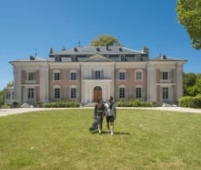
(3) Enter Vesancy on the Route de Bottenay, and continue straight ahead until you reach Rue du Château which crosses the village in front of the château. Continue to the intersection with the route de Divonne, then turn left onto route de la Chapelle. It climbs gently. At the next intersection, keep right. Follow the signs for the Chapelle de Riantmont. After roughly 500m, the road turns left and reaches the chapel.
(4) A beautiful panoramic view awaits you. Three orientation tables give you a better understanding of the landscape. Take a break at this peaceful spot before continuing on the route behind the chapel keeping to the left at the next three intersections, then crossing the route de la Vesancière. It skirts the edge of the forest, forks left, then descends towards a water reservoir. At the crossroads below, continue straight ahead on route de la Combette, then take the path to the right. This forest trail passes the houses of La Ganguillette and La Pinière, before reaching the locality of Saint Martin. Turn right at the cul-de-sac to enter the Nature Reserve. Follow this path for 600m to the highest point of Sous Disse.
(5) Turn left to descend the ridge into the woods. The path soon joins the locality of Chaumois via the Chemin de Chaumois.
(6) Go straight ahead, then take the Forêt de Disse road on the right. Follow this road, cross the Oudar river again and return to Le Pérsoset. From here, take the same route as before, back to the center of Gex, to Place Perdtemps.
Itinerary details
Description
The route runs through the heart of the Haut-Jura Regional Nature Park, and part of it passes through the Haute Chaîne du Jura National Nature Reserve: a protected, unspoilt area that should be explored with respect.
Good to know – Protected area
Part of the route passes through the Haute Chaîne du Jura National Nature Reserve, which is subject to special regulations:
Dogs are not allowed, even on a lead.
Please respect these rules to preserve the richness of this exceptional environment.