


▶Day 1: Bellegarde-sur-Valserine station -> La Ferme de Retord, approx. 4h50
Distance: 13.9 km
Difference in altitude: D+920 m/D- 20 m
Itinerary: Head towards Ochiaz via the GR (red and white), Catray, Pra de devant, la Charmy and la Ferme de Retord.
▶Day 2: Ferme de Retord -> Giron, approx. 8 hrs
Distance: 25.1 km
Difference in altitude: D+740 m/D- 1000 m
Itinerary: Follow the GR (red and white), then Pré Neyret, Col de Cuvéry, la Conay, Saint-Germain-de-Joux, Giron.
▶ Day 3: Giron -> Lélex village approx. 6h
Distance: 19.7 km
Difference in altitude: D+ 510 / D- 620 m
Itinerary: From Giron, follow Roche Fauconnière, Caserne, Sous le Crêt, Borne au Lion, Les Closettes, Le Niaizet, Lélex.
▶ Day 4: Lélex village -> Menthières, approx. 7h30
Distance: 21.6 km
Difference in altitude: D+1050 m/ D- 890 m
Itinerary: From Lélex follow signs for le Ratou, Refuge de la Loge, Crêt de la Neige, Reculet, refuge du Gralet, Refuge de la Poutouille, la Pelaz, Menthières.
▶Day 5: Menthières -> Bellegarde, approx. 6h00
Distance: 17.5 km
Difference in altitude: D+625 m / D-1324 m
Itinerary: From Menthières, la pierre à Fromage, Crêt de la Goutte, Sorgia d’en Haut, Sorgia d’en Bas, Métral, Lancrans, les pertes de la Valserine, Bellegarde station.
Itinerary details
Alert
Description
Hiking the Grand Tour de la Valserine is an adventure in the Jura, away from the crowds of the Alps and off the beaten track in unspoilt countryside.
You quickly leave the city behind and gradually gain height before reaching the vast expanses of the Plateau de Retord. At Catray, you’ll get a good overview of the road ahead and, if you’re lucky, a magnificent panorama of the Alps and their star: Mont Blanc. If you set off in spring, daffodils and narcissi will embellish your route!
Then head for the other side of the Jura mountains, passing through the highest commune in the Ain department, Giron, at an altitude of 1,000 metres. You’ll pass through places steeped in history, such as La borne au Lion, where the more courageous can take a detour via the famous Crêt de Chalam!
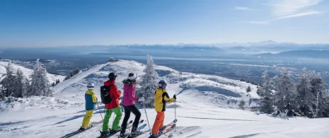
The Monts Jura resort, in the village of Lélex, will welcome you as you prepare to climb the highest peaks in the Jura: Crêt de la Neige (1720 m), Reculet (1717 m) and Crêt de la Goutte (1621)! You’ll cross the Haute-Chaîne du Jura National Nature Reserve, a veritable balcony overlooking breathtaking scenery. You’ll be overlooking Lake Geneva, and of course you’ll be able to admire all the ground you’ve covered on this grand tour – something to make you proud!
After a well-deserved break at the Menthières site, you’ll return to the Valserine valley, with its wild river, to finish in style with a passage through the Pertes de la Valserine, where the river winds its way through canyons before reappearing further on.
Finally, return to your starting point: Valserhône.
Good to know – Protected area
Part of the route passes through the Haute Chaîne du Jura National Nature Reserve, which is subject to special regulations:
Dogs are not allowed, even on a lead.
Bivouacs in tents are prohibited.
Please respect these rules to preserve the richness of this exceptional environment.