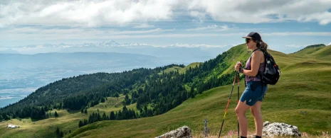


Itinerant hiking: the balcony of Lake Geneva
An exceptional route through the highest peaks of the Jura massif and the wild landscapes of the Haut-Jura plateau, with spectacular views of Lake Geneva and the Alps in the background.
▶ Day 1: Lélex → Mijoux
⏱ Approximately 4 h – 14.4 km – D+ 471 m / D- 372 m
Follow the yellow markings towards Moulin Pierre Louis, then pass through La Pralouse, Croaby and Sous Cariche. Rejoin the GR (red and white) to Le Manon, cross Lajoux and finish in Mijoux.
▶ Day 2: Mijoux → Refuge de la Loge
⏱ Approximately 6 h – 13.8 km – D+ 899 m / D- 451 m
Take the red and white GR, go through the village towards La Faucille. Continue towards Grand Mont Rond, Colomby de Gex, Col de Crozet, as far as Refuge de la Loge. You are partly in the National Nature Reserve.
▶ Day 3: Refuge de la Loge → Lélex (via Crêt de la Neige)
⏱ Approximately 5h30 – 12.8 km – D+ 416 m / D- 950 m
Follow the red and white GR towards Brillonne d’en Haut, les Brulats Frézy, sous le Crêt, then Crêt de la Neige and le Reculet. Then take the yellow PR back down to the Menues flat via the 32 contours, cross the road, then the Pont du Niaizet and end up in Lélex.
▶ 1ʳᵉ stage – Mijoux: Overnight stay at La Michaille or the Gîte Communal, for a warm and friendly welcome.
▶ 2ᵉ stage – Refuge de la Loge: Overnight in a mountain refuge, for an authentic immersion in the heart of the Jura crests.
Itinerary details
Alert
The descent of the 32 contours, just after the summit of Le Reculet, is relatively steep and requires a little care, especially in wet or slippery conditions.
Description
An exceptional route through the highest peaks of the Jura massif and the wild landscapes of the Haut-Jura plateau, with spectacular views of Lake Geneva and the Alps in the background.
The route takes in the heart of the Haut-Jura Regional Nature Park, and part of the Haute Chaîne du Jura National Nature Reserve: a protected, unspoilt area to be explored with respect.
Good to know – Protected area
Part of the route passes through the Haute Chaîne du Jura National Nature Reserve, which is subject to special regulations:
Dogs are not allowed, even on a lead.
Camping in tents is prohibited.
Please respect these rules to preserve the richness of this exceptional environment.
The trail passes through a Quiet Zone, which is closed from December 15 to June 30.
An exception is made for use of the GR trail, provided that you stay strictly on the marked path. It is prohibited to stray from the path.