Loop
in Mijoux

Ecureuil snowshoe trail

This easy loop trail runs entirely along the Vattay plateau in the Haute Chaîne du Jura Nature Reserve, through open, wooded countryside that is ideal for a family outing or a peaceful exploration of the great outdoors.
Guidebook with maps/step-by-step

(1) Start: From the starting area at the Domaine de la Vattay, follow the log barriers to the control chalet.

(2) Follow the direction of the plateau, then enter the forest on a wide track.

(3) After about 500 m, you will come to a more open area. The trail runs alongside and between the two cross-country ski trails until the next intersection.

(4) Turn left and complete the loop on the other side of the plateau.

(5) At this point, the Écureuil trail joins the Chouette and Gelinotte trails, which come in from the right. The trail that begins the return journey is on the left.

(2) You will then rejoin the outbound trail, which leads you gently to the finish at La Vattay after one last climb.

Itinerary details

Mijoux
Loop
Marked
Groomed trail
Autumn, Winter, Spring
Pets are not allowed
From 20/12 to 29/03 daily between 9 am and 5 pm.Open when the Domaine de la Vattay is open.Subject to favorable snow and weather conditions.

Description

Perfect for a family outing or a first snowshoeing experience. The trail winds gently through the forest before looping back to the plateau. It's the ideal opportunity to enjoy the peace and quiet of nature and gently ease yourself into winter hiking.
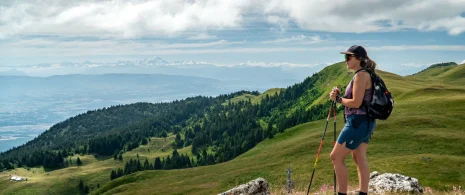
Throughout the route, specific markings guide you along well-trodden paths with little elevation gain, but a wonderful feeling of escape. Walkers are rewarded with beautiful views of the Dôle, the iconic peak of the Swiss Jura.

The start and finish are at the Domaine de la Vattay, where there is an entrance fee. As with any route through a protected natural area, it is essential to respect the regulations in force (no dogs, stay on the marked trails, no unnecessary noise, etc.).
Free car parkCar parkPublic WCWinter sportsSnowshoe itinerary
DifficultyEasyDuration01h45Elevation39 D- / 39 D+Distance3.7 kmAltitude Max.1409 m
Download

Ce contenu vous a été utile ?