


Cycling route: From Thoiry to the Balcony of Geneva
The route from Thoiry to the Geneva balcony offers a long, challenging loop through the Geneva plain, the Mandement vineyards and up the Salève, with spectacular views over Geneva and Lake Geneva.
Start / Finish: Thoiry (~500–600 m)
Km 0 — Start from Thoiry
Access road from the north, followed by a series of small local roads. Warm-up.
Km 2 to 5 — Thoiry area / plain
A mix of minor roads and cycle paths. Winding route.
Km 5 to 15 — Towards Le Mandement
Entry into Switzerland. Fast-paced sections through vineyards and villages (Bourdigny, Satigny). Favourable terrain.
Km 15 to 27 — Towards Frangy / D992
Faster section with some wider roads. ⚠️ Traffic possible.
Km 27 to 33 — Climb towards Mont-Sion
The difficulties begin. Gradual gradients.
Km 33 to 50 — Ascent of the Salève (D41A)
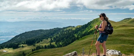
⚠️ Major climb of the route (~12 km). A long, steady effort to the summit (~1,300 m). Exceptional views.
Km 50 to 62 — Salève ridge and balcony
High-altitude section, undulating terrain with unobstructed views.
Km 62 to 70 — Descent from Salève
⚠️ Technical descent towards the valley. Caution advised.
Km 70 to 78 — Saint-Julien area / Geneva outskirts
More urbanised area. Alternating roads and cycle paths.
km 78 to 90 — Return via the plain
Dense network of small roads and cycle paths. Winding but fast-flowing route.
km 90 to 98 — Return to Thoiry
Final kilometres similar to the outbound leg. Slight climbs.
km 97.9 — Finish in Thoiry 🏁
These road bike itineraries are for guidance only, and are aimed exclusively at experienced cyclists.
Important information before you set off:
▶These routes are not marked on the ground and require the use of a GPS or navigation app.
▶The routes use roads open to motorized traffic. Compliance with the Highway Code is mandatory.
▶These routes are recommended for experienced cyclists in good physical condition who have mastered the art of road biking.
▶We advise you to check weather conditions before setting off and adapt your outing accordingly.
Itinerary details
Alert
A road shared with motorists.
Description
This route is a complete and challenging loop. It is designed for experienced cyclists looking for a varied route between France and Switzerland, combining fast-paced sections, long climbs and exceptional views.
Starting from Thoiry, the route quickly reaches the Geneva plain via a series of secondary roads and cycle paths. It then crosses the Mandement vineyards, particularly around Bourdigny and Satigny, in an open and gently undulating landscape, ideal for getting into your stride.
After this rolling start, the route gradually increases in intensity towards Mont-Sion and then the Salève. The climb up the Salève is the highlight of the route: a long, steady ascent of around 12 km leading up to the natural viewpoint overlooking Geneva. The reward is spectacular views of the Lake Geneva basin and the Alps.
The descent then takes place on the valley side, before reaching more urban areas around Saint-Julien-en-Genevois, and then returning to a network of small roads and cycle paths heading towards the plain.
The end of the route partly retraces the sections from the start, alternating between rolling sections and gentle climbs until the return to Thoiry.
A challenging and demanding route, marked by the climb up the Salève and the variety of landscapes encountered.
This route is provided for guidance only and is intended exclusively for experienced cyclists.
▶▶Important information before you set off:
This route is not signposted and requires the use of a sat-nav. It follows roads open to traffic, which can be busy at times, particularly in urban and cross-border areas. You must comply with the Highway Code. A very good level of fitness is required. Remember to check the weather conditions, particularly at higher altitudes.