


Cycling route: La Traversée du Sud Gessien
The Traversée du Sud Gessien route links Thoiry via the villages of Farges, Collonges, Péron and Saint-Jean-de-Gonville. A rolling route through the forests and countryside of the Gesse region, on the outskirts of Geneva.
These road bike itineraries are for guidance only, and are aimed exclusively at experienced cyclists.
Important information before you set off:
▶These routes are not marked on the ground and require the use of a GPS or navigation app.
▶The routes use roads open to motorized traffic. Compliance with the Highway Code is mandatory.
▶These routes are recommended for experienced cyclists in good physical condition who have mastered the art of road biking.
▶We advise you to check weather conditions before setting off and adapt your outing accordingly.
Km 0 — Start in Thoiry
Take the western access road for 1.88 km towards Farges.
Km 1.9 — Keep right towards Route de la Cendière, D89
Follow the D89 for 1.25 km on a slight downhill stretch.
Km 3.1 — Turn left onto Rue de l’Église
Cross the village for 113 m.
Km 3.2 — Turn right onto Rue de l’Église, D89e
Continue for 149 m.
Km 3.4 — Turn left onto Route de Goisin, D89e
Follow for 53 m then turn right onto Route des Cheneviers.
Km 3.7 — Turn right onto Route des Cheneviers
Follow for 270 m towards Collonges.
Km 4.0 — Keep left onto Route de Choudans
Follow for 1.03 km. A lovely road through fields and woods.
Km 5.0 — Keep right, still on Route de Choudans
Continue for 540 m.
Km 5.5 — Turn left onto Rue de l’Ancienne Fruitière
Follow for 174 m, passing through a hamlet.
Km 5.7 — Keep left towards Route de Chanvière
Follow for 1.38 km.
Km 6.8 — Turn right towards Route de Saint-Jean-de-Gonville, D89e
Follow for 906 m towards Saint-Jean-de-Gonville.
Km 7.7 — Turn right onto the Grand Rue
Cross the village for 546 m.
Km 8.4 — Turn left onto the Route de la Combe de Péron
Follow for 242 m then turn left again.
Km 8.7 — Turn left, still on the Route de la Combe de Péron
Continue for 642 m. ⚠️ Gradual climb towards Péron.
Km 9.3 — Straight on towards Rue de la Fontaine Chargonnet
Follow for 30 m then keep left at the fork for 758 m.
Km 10.1 — Keep left towards Rue du Branlant
Continue for 236 m. Pass through Péron.
Km 10.3 — Turn right onto Route de Lyon, D984
⚠️ Busier road. Follow the D984 for 1.20 km.
Km 11.5 — Keep right towards Rue Pierre Malfant
Follow for 118 m then keep right again for 109 m.
Km 11.8 — Straight ahead, Rue Pierre Malfant
Long straight stretch of 2.06 km. Flat terrain.
Km 13.8 — Turn right onto Chemin des Refats
Follow for 37 m then turn left onto the cycle path for 640 m.
Km 14.5 — Turn left onto Rue de la Chenaz, then right onto Route du Pays de Gex, D984
Follow the D984 for 512 m.
Km 15.1 — Keep right onto Route du Pays de Gex, D984b
Continue for 50 m, then turn left onto a minor road.
Km 15.5 — Slightly right, then right onto Rue de l’Étournelle
Follow for 71 m, then turn left for 188 m.
Km 15.8 — Turn right onto a road
Follow for 256 m.
Km 16.1 — Slightly right towards Route de Pierre d’En Bas
Follow for 1.37 km. Beautiful countryside.
Km 17.5 — Turn right towards Rue du 19 Août 1944, then left towards Route des Posés
Follow Route des Posés for 1.69 km.
Km 19.2 — Turn right onto the D76
⚠️ Follow the D76 for 3.03 km. Watch out for traffic.
Km 22.3 — Keep left onto a track
Follow for 178 m.
Km 22.5 — Turn left onto Route de la Chapelle, D76b
Follow the D76b for 3.95 km. A quiet road with views of the Gesse countryside.
Km 26.4 — Turn right onto Route de Lyon, D984
Continue for 1.05 km.
Km 30.4 — Turn right onto Route de Roulave, D89h
Continue for 812 m.
Km 31.3 — Keep left onto the cycle path
Final 3.45 km section on the cycle path. Flat terrain for a gentle finish towards Thoiry.
Km 34.7 — Keep left towards Chemin de la Praille, then keep right
Final metres before the finish.
Km 36.2 — Finish in Thoiry 🏁
Itinerary details
Alert
A road shared with motorists.
Description
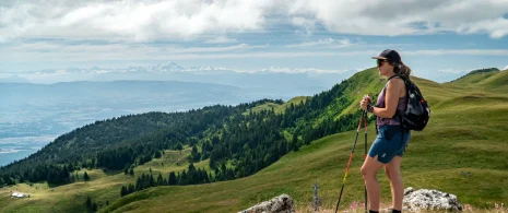
This route takes you on a beautiful circular cycle ride starting from Thoiry, on the edge of the Pays de Gex. The route heads west towards Farges and Collonges, running alongside the foothills of the Jura Mountains. It then climbs up the Route de Choudans before passing through the villages of Saint-Jean-de-Gonville and Péron. The return journey follows the Route de la Chapelle and the D76, offering lovely views of the Gex countryside, before a final stretch along a cycle path back to Thoiry. A varied route, alternating between steady climbs, descents and fast-paced sections in a lush green setting.
▶▶This road cycling route is provided for guidance only and is intended exclusively for experienced cyclists.
Important information before you set off:
This route is not signposted and requires the use of a GPS or navigation app. The route uses roads open to motor traffic: compliance with the Highway Code is mandatory. A good level of fitness and proficiency in road cycling are essential. Please also remember to check the weather conditions before setting off and adapt your ride acc