


Cycling route: The Borderless Vineyard Route
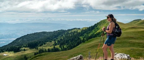
The Route des Vignes sans Frontières links Challex to Dardagny, winding its way through vineyards and villages on both the French and Swiss sides of the border. Stretching between the Rhône Valley and the Mandement Plateaus, it offers a varied route through stunning countryside.
Km 0 — Start from Challex (501 m)
Take the eastern access road for 500 m. Immediate descent towards the plain.
Km 1.6 — Turn slightly right onto Route de la Plaine, D89 (425 m)
Follow the D89 for 1.35 km. The descent continues towards the Rhône.
Km 2.9 — Keep right at the fork, Route de la Plaine D89 (348 m)
Lowest point of the route. Flat terrain along the Rhône plain.
Km 3.5 — Right, then immediately left onto the cycle path (351 m)
Follow the cycle path for 516 m. A pleasant stretch along the edge of the plain.
Km 3.6 — Left, then right towards Route de Challex (351 m)
A short 72 m stretch before rejoining the cycle path on the left.
Km 3.75 — Turn right onto Chemin Rey, then right onto Chemin du Rail (353 m)
A short transition before joining Route de la Plaine.
Km 4.4 — Turn left onto a path, then turn right (353 m)
Follow this path for 689 m. The road begins to climb slightly.
Km 5.0 — Turn left onto Route du Mandement, D110 (359 m)
⚠️ Start of the climb towards the heights of Mandement. Follow the D110 for 1.82 km.
Km 6.9 — Turn left, still on Route du Mandement D110 (426 m)
Continue for 297 m. The climb continues.
Km 7.2 — Keep right towards Route de Malval (439 m)
Follow Route de Malval for 1.68 km. A lovely climb with views of the vineyards.
Km 8.85 — Turn left, still on Route de Malval (450 m)
Continue for 742 m.
Km 9.6 — Turn right onto Route de Malval (456 m)
Continue for 1.04 km. Dardagny area, passing through the Mandement vineyards.
Km 10.6 — Turn left onto Route de l’Allondon (400 m)
⚠️ Slight descent. Follow Route de l’Allondon for 2.86 km along the river. Crossing into Swiss territory.
Km 13.5 — Turn left onto Route de Peissy (473 m)
Climb back up to higher ground. Continue for 469 m.
Km 14.0 — Turn left onto Route de Crédery (484 m)
Continue for 648 m. ⚠️ The climb becomes steeper.
Km 14.6 — Keep right at the fork (495 m)
Follow the road for 284 m, then turn left for 23 m.
Km 14.9 — Turn right onto Route de Crédery (500 m)
Continue for 421 m.
Km 15.3 — Turn right onto Rampe de Choully (505 m) 🏔️
Highest point of the route. Continue for 922 m. Panoramic views of the vineyards and the Geneva countryside.
Km 16.3 — Turn right onto Route du Mandement D110 (435 m)
Start of the descent. Continue for 153 m.
Km 16.4 — Turn left onto Route d’Aire-la-Ville (428 m)
Continue for 313 m towards Aire-la-Ville.
Km 18.6 — Straight ahead, Route d’Aire-la-Ville (374 m)
Pass through Aire-la-Ville. Flatter terrain along the banks of the Allondon.
Km 20.1 — Turn right onto the cycle path (384 m)
Keep left at the junctions. Follow the path for 430 m.
Km 20.6 — Turn right onto Chemin de Treulaz (409 m)
Follow this road for 430 m before joining Route du Moulin de la Ratte.
Km 22.3 — Turn right onto Route du Moulin de la Ratte (429 m)
Follow this road for 1.74 km. A pleasant, shaded stretch.
Km 25.2 — Turn right onto Route du Moulin-Roget (417 m)
Follow Route du Moulin-Roget for approximately 2 km. Smooth terrain.
Km 27.2 — Straight ahead, Route du Moulin-Roget (372 m)
Continue for 54 m then turn right onto the cycle path.
Km 27.8 — Cycle path, keep left at the fork (362 m)
Follow for 475 m before joining the Route de Bellegarde.
Km 28.1 — Slightly right onto the Route de Bellegarde, D103 (361 m)
⚠️ Back on French territory. Follow the D103 for approximately 1.4 km. Collonges area.
Km 29.0 — Straight ahead, Route de Bellegarde D103 (339 m)
Final low point. Continue for 452 m.
Km 29.5 — Right onto Route de la Chapelle, D76 (351 m)
Immediate left-hand bend, follow the D76 for 266 m.
Km 29.8 — Turn right, still on Route de la Chapelle D76 (368 m)
⚠️ Start of the final climb towards Challex. Continue for 465 m.
Km 30.2 — Keep right onto Route de la Chapelle, D76b (390 m)
Final climb. Follow the D76b for 4.17 km without stopping until the finish. The gradient is steady and sustained.
Km 34.4 — Finish in Challex (494 m) 🏁
These road bike itineraries are for guidance only, and are aimed exclusively at experienced cyclists.
Important information before you set off:
▶These routes are not marked on the ground and require the use of a GPS or navigation app.
▶The routes use roads open to motorized traffic. Compliance with the Highway Code is mandatory.
▶These routes are recommended for experienced cyclists in good physical condition who have mastered the art of road biking.
▶We advise you to check weather conditions before setting off and adapt your outing accordingly.
Itinerary details
Alert
A road shared with motorists.
Description
This route takes you on a beautiful circular cycle ride starting from Challex, between the Pays de Gex and the canton of Geneva. The route first descends towards the Rhône plain before following the river towards Pougny. It then climbs back up to the heights of Mandement on the Swiss side, passing through vineyards and typical villages such as Dardagny, Russin and Aire-la-Ville. After a stretch along the Allondon, the route follows the Route du Moulin-Roget before reaching Collonges and heading back up to Challex via the Route de la Chapelle. A rewarding Franco-Swiss route, combining vineyard landscapes, riverside paths and green plateaus.
This road cycling route is provided for information purposes only and is intended exclusively for experienced cyclists.
▶▶Important information before you set off:
This route is not signposted and requires the use of a GPS or navigation app. The route uses roads open to motor traffic: compliance with the Highway Code is mandatory. A good level of fitness and proficiency in road cycling are essential. Please also remember to check the weather conditions before setting off and adapt your ride accordingly.