


VTTAE 86 course – red – La Panoramique – Espace VTT FFC Ain Forestière


Start from the Col de la Faucille. Follow the GR signs (red and white) southwards. Pass between the ski pass sales chalet and the start of the toboggan run.
Continue on this road for 8.14 km. You’ll pass the Giant Tyrolean traverse.
You reach the Maréchaude chalet, where the road ends. The trail continues on foot to the Col de Crozet.
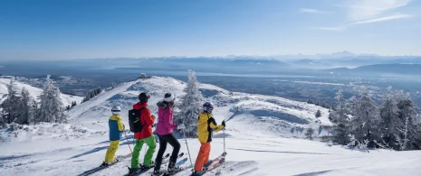
Once on the pass, take a moment to enjoy the unobstructed view of Mont Blanc and the Lake Geneva basin.
Begin the descent to Crozet via the route du Col.
The first section is a stony white road.
The second part becomes a forest road.
As you descend, you pass the Pré Galet forest chalet. At this crossroads, keep right, then left at the next intersection, in the direction of Gex.
Continue on this road for about 5.5 km, then turn right onto the “chemin Neuf”.
Continue under the Branveau sector, you’ll come to Les Platières, then to Le Pailly.
At Pailly, turn left onto the Col de la Faucille road and climb back up to the starting point.
Itinerary details
Description
This route alternates between forest paths, white roads and road sections. The gradual climb takes you up to the Col de Crozet, where, on a clear day, you can see Mont Blanc and the Lake Geneva basin.
The route passes through the Haute Chaîne du Jura nature reserve. It is important to find out about the regulations in force before entering (access, traffic, wildlife, etc.).
An accessible route that combines diversity of terrain and scenic points of interest.